Country facts, administrative boundaries and regional statistics, for interactive geography.
Quick Install
Automated & IDE SetupCopy the AI prompt to install this server into Claude Code, Cursor, or another agent — or use 1-click editor setup below.
One-click editor setup isn’t available for this listing yet — we don’t have a confirmed install command, and we’d rather show nothing than point your editor at the wrong package or host. Follow the project’s own setup instructions, linked above.
Manual Client & Custom JSON ConfigExpand JSON ▾
No confirmed setup config for this listing yet. We only publish a config block when the install details come from the project itself — its README, its docs, or a verified owner. We haven’t found those for geo-explorer-mcp, and we’d rather show nothing than a guess you’d paste into your client. Follow the project’s own setup instructions for the current steps.
Documentation Overview
geo-explorer-mcp
An MCP server that serves country facts, administrative boundaries and regional statistics as structured data, so an AI assistant can build interactive geography instead of reciting it.
The server deliberately returns data, not prose. It hands back populations, polygons and coordinates; the model decides how to present them — as a clickable map, a comparison table, or a lesson in Slovak, German or Hungarian. Nothing in this server knows how to translate, and it does not need to.
Tools
| Tool | Arguments | Returns |
|---|---|---|
get_country_profile | country | Capitals with coordinates, population, area, region, currencies, languages (English and native names), bordering countries, flag, Wikipedia link |
get_map_data | country, level = ADM0 | ADM1 | ADM2 | Region names and a browser-fetchable GeoJSON URL, plus source, licence, vintage and data-quality warnings |
get_region_details | country | Per-region population, area, capital city (with its own population and coordinates), native names, subdivision type, Wikidata and Wikipedia links |
country accepts a name in almost any language — Slovakia, Slovensko,
Magyarország, Magyarorszag (no diacritics), Deutschland, Ungarn.
The two boundary and statistics tools are designed to be joined:
get_region_details returns a match_key per region, and a join_hint
telling the model how to normalise get_map_data's names to match it.
Quick start
Copy .env.example to .env and fill it in:
GEO_EXPLORER_CONTACT goes into the User-Agent sent to Wikidata. Wikimedia
requires a contact URL or email and answers anything else with 403.
Once published to PyPI it also installs with no clone at all:
Try it in the MCP Inspector:
Claude Desktop
Add this to claude_desktop_config.json (on Windows,
%APPDATA%\Claude\claude_desktop_config.json), adjusting the paths:
Pointing at the project's own .venv interpreter means Claude runs exactly what
you tested, with no second environment to keep in sync. Restart Claude Desktop
fully afterwards — the config is only read at startup.
Then ask it something like:
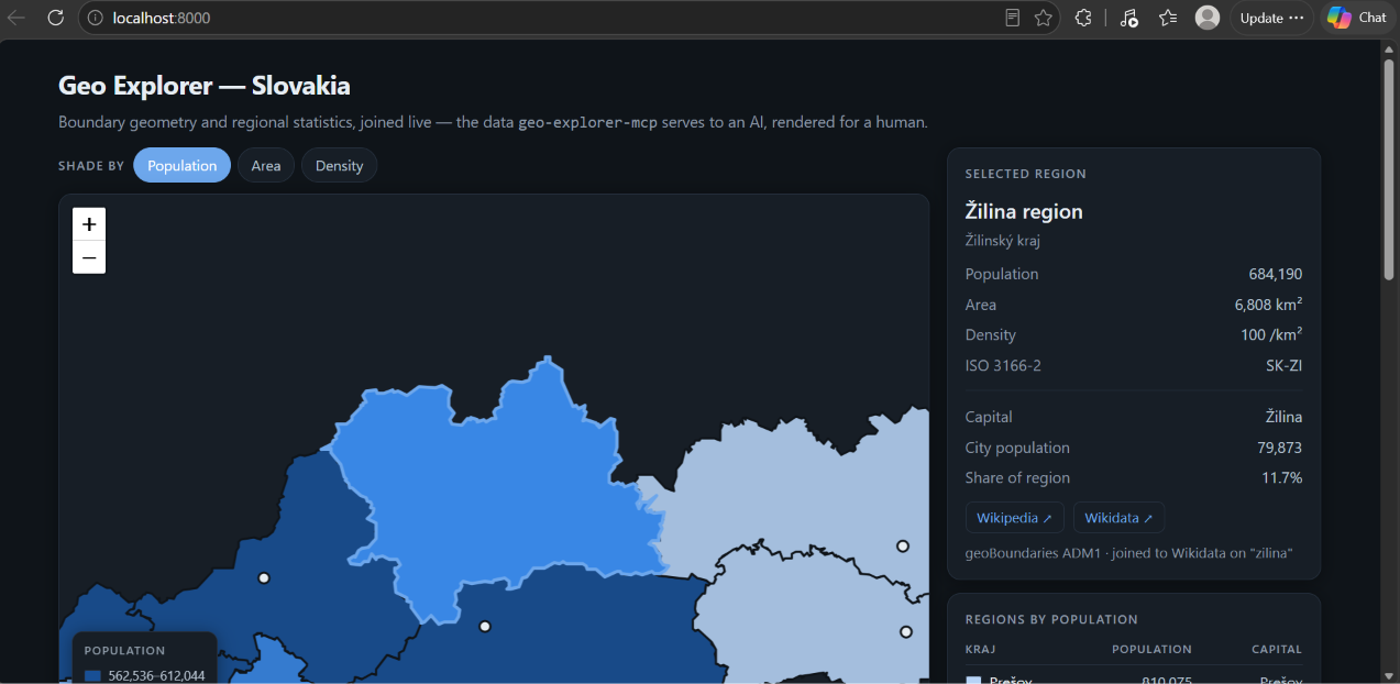
Show me an interactive map of Slovakia's regions, shaded by population, in German.
Demo page
demo/index.html renders any of four countries from the same two sources the
server uses, joined in the browser: shading by population, area or density,
capital markers, a sortable table, and per-region links to Wikipedia and
Wikidata. One page, parameterised by country — because the server is generic.
It must be served over http, not opened as a file — a file:// page has a
null origin and the browser blocks its cross-origin fetches:
| Regions | Joined to statistics | |
|---|---|---|
| Slovakia | 8 kraje | 8 |
| Germany | 16 Bundesländer | 16 |
| United Kingdom | 4 countries | 4 |
| United States | 56 states and territories | 55 |
The single US miss is the Virgin Islands, which has no ISO 3166-2 entry in Wikidata. Regions without a match render grey rather than being dropped.
Layout
server.py at the root re-exports the server object, so the Claude Desktop
config, fastmcp dev inspector server.py and the probe scripts all keep working
while the package underneath stays publishable.
Tests
probe2.py runs all four demo countries and asserts two things that previously
broke: that geojson_url is the resolved Git LFS media URL, and that at least
90% of boundary regions join to their statistics. Germany sat at 50% before
native-name matching landed.
Field notes
Things that cost real debugging time, written down so they don't cost yours.
REST Countries v3.1 is gone. Nearly every tutorial online still uses it. v5
lives at a different host, requires a bearer token, and renamed every field
(area → area.kilometers, cca3 → codes.alpha_3, and capitals is now an
array of objects, not strings).
geoBoundaries GeoJSON is stored in Git LFS, and only
media.githubusercontent.com serves it to a browser:
raw.githubusercontent.com/...returns a 131-byte LFS pointer file, not geometry.- The
github.com/.../raw/...URL the API publishes 302-redirects with an emptyaccess-control-allow-origin. Browsers enforce CORS on every hop of a redirect, so a page fetching it fails withTypeError: Failed to fetcheven though the final response sendsaccess-control-allow-origin: *.
Either mistake produces a blank map with no error. get_map_data resolves the
redirect and returns the URL that actually works.
Verifying with curl does not verify browser behaviour. curl -L followed
that redirect happily and reported the permissive header on the final response.
It ignores CORS entirely. Test cross-origin fetches with an Origin header, or
in a browser.
Wikidata's area property mixes units. P2046 values are entered in square
kilometres, hectares or square metres, and the raw number carries no hint
which. Reading it directly gave Békéscsaba an area of 193,930,000 km² — it is
193.9 km², recorded in m². Use the normalised value
(p:P2046/psn:P2046), which Wikidata converts to SI base units.
ISO 3166-2 mixes administrative levels. Hungary returns 43 subdivisions: 19
counties, Budapest, and 23 cities with county rights. The cities sit inside the
counties, so their areas and populations must not be summed, and there are far
fewer boundary shapes than entries. get_region_details returns
subdivision_types and warns via data_quality_notes.
Country-name matching folds case but not diacritics. Magyarország resolves;
Magyarorszag does not. Translations (Ungarn, Hongrie) are excluded from the
name aggregate on purpose. The server works around both with a three-step
fallback: the name aggregate, then the translations endpoint, then a locally
built diacritic-folded index.
A Wikidata query that works for a small country can time out for a large
one. Resolving subdivisions via ?i wdt:P17 ?country makes Wikidata scan
everything in that country: fine for Slovakia, HTTP 504 for the United States.
Filtering on the ISO 3166-2 prefix instead — FILTER(STRSTARTS(?iso, "US-")) —
returns the same 56 rows in 0.9 seconds, because those codes are defined as
<alpha-2>-<subdivision>, so the prefix already is the country filter.
The same region has different names in each source. geoBoundaries says
Bayern, Sachsen, Thüringen; Wikidata's English labels are Bavaria,
Saxony, Thuringia. Matching on the English label alone joined 8 of Germany's
16 states. Building a key from every name variant, native names included,
joins all 16 — which is why get_region_details returns match_keys (plural).
A bounding box lies about shapes that cross the antimeridian. Alaska's
Aleutian Islands run past 180°, so its box reads -179.15 .. 179.78 — a
359-degree span. fitBounds on that zooms out to the whole globe and shrinks
the mainland to a smudge, with no error. Russia, Fiji and New Zealand share the
trap. The demo refuses any box wider than 180° and falls back to a fixed view.
The hidden attribute loses to any author display rule. It works through
the browser's default stylesheet, the weakest source there is, so an element
styled display:grid stays visible when you set hidden. Symptom: a loading
overlay that never goes away, covering a map that loaded perfectly. Guard it
with [hidden]{display:none !important}.
Some upstream region names are damaged. geoBoundaries' ADM2 names for
Slovakia are truncated and mistransliterated (Prešov → Predov, Dolný Kubín
→ Dolne Kub). The geometry is fine. get_map_data detects this and returns a
data_quality_note so a model does not present corrupted names as fact.
No # comments inside a SPARQL query that gets collapsed to one line. In
SPARQL # comments out the rest of the line; after collapsing, that is the
entire query. Symptom: HTTP 400.
Data sources
| Source | Used for | Licence |
|---|---|---|
| REST Countries v5 | Country facts | Free tier, API key required |
| geoBoundaries | Administrative boundaries | CC BY 4.0 / ODbL, varies per country — the tool returns the actual licence per request |
| Wikidata | Regional statistics, capitals, links | CC0 1.0 |
Related MCP Servers
Reviews
No reviews yet — be the first to share how this listing worked for you.
Frequently Asked Questions about Geo Explorer MCP
AllMCPs Directory Badge
Showcase your server listing on GitHub or your project documentation. Embed this dynamic SVG badge to highlight official listing status and live engagement.
Badge Style:
Live Dynamic SVG Preview
Markdown (GitHub README)
[](https://allmcps.com/mcp/geo-explorer-mcp)HTML Embed
<a href="https://allmcps.com/mcp/geo-explorer-mcp"><img src="https://allmcps.com/api/badge/geo-explorer-mcp?style=directory" alt="Geo Explorer MCP on AllMCPs" /></a>